
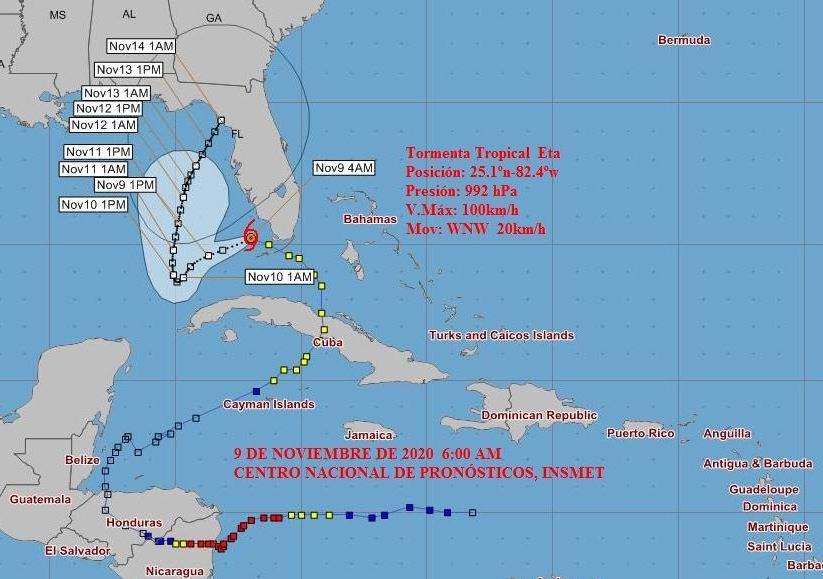
Eta in the early morning has had little change in organization and intensity, although satellite images show an increase in the activity of heavy showers around the center of circulation. This indicates a trend towards a better organization of its structure, however it maintains maximum sustained winds of 100 kilometers per hour, with higher gusts, with a central pressure of 992 hectoPascal, Radio Rebelde publishes.
In the last hours it continued its trajectory to the west-northwest, slightly decreasing its speed of translation to 20 kilometers per hour.
At six o’clock in the morning its central region was estimated at 25.1 degrees North latitude and 82.4 degrees West longitude, a position that places it about 210 kilometers north of Havana and about 260 kilometers north-northeast of Bahía Honda, Artemisa .
In the next few hours Eta will incline its course to the west-west in the morning and to the southwest since the afternoon, going further into the Gulf of Mexico. During this displacement, it can gradually gain in organization and intensity, with the possibility of turning into a hurricane tomorrow, Tuesday, in the southeast of the Gulf of Mexico.
The areas of showers and rains associated with the wide circulation of Eta, have continued affecting the western half of the archipelago, as well as the eastern end, with some electrical storms. These have become strong in some points of the provinces of Sancti Spíritus and Guantánamo: between one and four in the morning, 48 millimeters were recorded in the city of Sancti Spíritus, 39 millimeters in Caujerí, Guantánamo and 28 millimeters in the main city of the latter province.
The rain bands, with some thunderstorms, will continue to influence the west and center, as well as the south east, where they can still become strong and locally intense mainly from late morning. Given the abundant rainfall received in the last 48 hours, with the saturation in the soils, accumulated not so significant, they can cause floods in low areas and difficult drainage.
From the end of the morning the force of the winds will increase in the western north coast, with speeds between 25 and 40 kilometers per hour and higher gusts in the rainy areas. These winds can be somewhat stronger at night in areas of the north coast of the province of Pinar del Río and the extreme west.
Since the morning the swells will decrease on the north coast of the west, which will remain in the afternoon in the north of the extreme west.
The next tropical cyclone advisory on this tropical organism will be issued at nine in the morning today.