
During the morning, the center of tropical storm Laura has transited over the seas to the south of the central region of Cuba, over the Jardines de la Reina archipelago. The clouds and rains continue to affect the eastern provinces, which will extend over the next few hours to Ciego de Ávila, Sancti Spíritus and Cienfuegos, and will be strong and intense in some locations, mainly in mountainous areas, Cubadebate publishes.
These winds will increase until reaching speeds between 65 and 80 kilometers per hour and higher gusts that could exceed the 100 kilometers per hour, which will gradually spread from this morning to the rest of the central region. In Guantánamo and Santiago de Cuba the force of the winds will continue to decrease, as will the storm surge, although in areas of showers and thunderstorms strong winds can be registered in gusts and significant wave heights.
Strong swells with light coastal flooding will continue on the north coast from Holguín to Ciego de Ávila, which will spread to the rest of the north central coast in the course of the morning. Light to moderate coastal flooding will be generated on the southern coast of Las Tunas and Camagüey in the next few hours, which will reach the south central coast in the morning.
The cloudy areas with heavier rains are located in the southern semicircle of this system, on the southern eastern portion and seas adjacent to Jamaica, some areas of heavy rainfall persist over Santiago de Cuba and Granma.
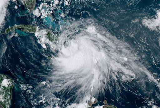
At nine in the morning, Laura’s center was estimated at 21.0 degrees North latitude and 79.4 degrees West longitude, a position that places it about 135 kilometers southeast of the city of Cienfuegos and 275 kilometers southeast of Punta Gorda. , Peninsula de Zapata, Matanzas.
The tropical storm has continued to move rapidly west-northwest, at a rate of 33 kilometers per hour. Its maximum sustained winds are maintained in the order of 100 kilometers per hour, with higher gusts, and the central pressure is 1000 hectoPascal.
Tropical storm Laura will continue to transit with a similar course and speed of translation, moving through the seas to the west of the Jardines de la Reina archipelago, south of Santi Spíritus, to settle at the end of the morning at a point in the seas south of Cienfuegos. It is predicted that in the next few hours it may gain something more in organization and intensity, as its center will move over warm waters.
The bands of cloudy with showers and rains associated with the tropical storm continue over the eastern provinces. In the last hours, heavy rains have been registered in the eastern provinces. The most significant accumulated were: Valle del Caujerí, Guantánamo with 130 millimeters and 122.2 millimeters in the city of Santiago de Cuba and Jamal in Guantánamo with 120 millimeters.
At the weather station of Cabo Cruz, Granma, a gust of wind that reached 104 kilometers per hour from the south was recorded at 4 in the morning, with sustained winds of 80 kilometers per hour.
The next tropical cyclone advisory over Laura will be issued at noon today.