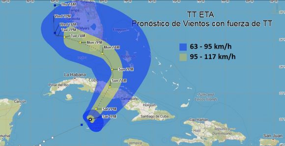
Cuba: At noon today, the central region of Tropical Storm Eta was estimated at 19.8 degrees North latitude and 81.3 degrees West longitude, 55 kilometers north of Cayman Grande, and 260 kilometers south-southwest of Trinidad, Sancti Spíritus. Eta is moving rapidly east-northeast at a rate of 28 kilometers per hour, Cubadebate publishes.
In the next 12 to 24 hours, Eta will move in a near northeast course with similar speed. A gradual intensification of the system is forecast, as it approaches Cuban territory. With this course and speed of translation, Eta will approach the seas to the south of the central region of Cuba from tonight, increasing the rains in much of the archipelago, which can be strong and intense, mainly in mountainous areas and the south coast, even in locations far from the center of circulation of the organism.
From the end of the afternoon today, the winds with tropical storm force will increase, between 80 and 100 kilometers per hour, with higher gusts in the central region of Cuba.
These winds will produce strong swells on the south coast, with sea level rise between 1 and 1.5 meters and light to moderate coastal flooding from Casilda in Sancti Spíritus to Manzanillo in Granma.
Due to the combination of the effects of the wind, heavy rains and the sea in the area of the mouth of the Zaza and Cauto rivers, floods in these areas are forecast to be strong.
Residents throughout Cuba must carry out risk prevention and mitigation measures in the face of the imminent impact on this system, as weather conditions will gradually deteriorate from today´s evening.
Once again, it is recommended not to focus on the exact location of the track cone, as bands of rain and strong winds can be experienced outside the cone boundaries. People are encouraged to pay special attention to the information from the Forecasting Center of the Institute of Meteorology and the instructions from the Civil Defense.

Redacción Digital
Equipo de redactores del sitio web de Radio Mayabeque


