
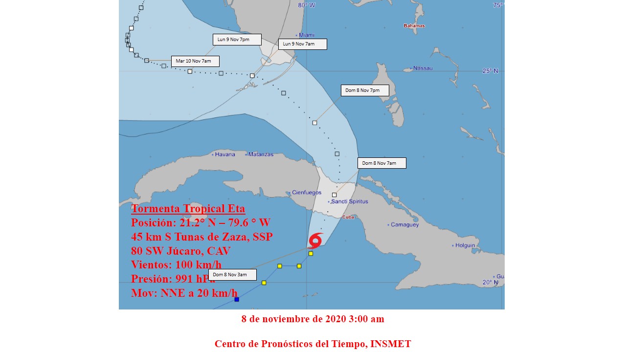
According to data from surface weather stations and observations from weather radars, Eta entered the southern coast of Cuba around 4:30 am on the border between the provinces of Sancti Spíritus and Ciego de Ávila. Its maximum sustained winds continue to be 100 kilometers per hour, with higher gusts, and its central pressure remains at 991 hectoPascal, the Institute of Meteorology publishes.
At six in the morning its central region was estimated at 21.8 degrees North latitude and 78.7 degrees West longitude, over the city of Ciego de Ávila. Eta is moving northeast at a rate of 19 kilometers per hour.
In the next few hours Eta will maintain a close course between north-northeast and north, tilting its trajectory to the northwest from noon with a slight decrease in its speed of translation. A slight weakening is forecast while it transits over Cuban territory. With this course and speed, Eta will continue crossing over the province of Ciego de Ávila, leaving in the morning by the north coast of this province.
The bands of rains related to the circulation of Eta continue to affect central and eastern Cuba, which will gradually spread to the western provinces and can be strong and intense, mainly in mountainous areas and the central region, even in locations far from the center of circulation of the organism. In the last hours, the most significant accumulated was recorded at the El Jíbaro station, Sancti Spíritus, with 219 millimeters, followed by the Venezuelan weather stations with 119 millimeters, Júcaro with 99 millimeters and Falla with 77 millimeters, the latter in the province of Ciego de Ávila.
In the next few hours, the winds with tropical storm force will continue, between 70 and 95 kilometers per hour in the central region of Cuba, with higher gusts.
These winds will produce strong swells on the south coast, with sea level rise between 1 and 1.5 meters and moderate coastal flooding from Júcaro in Ciego de Ávila to Manzanillo in Granma.
Due to the combination of the effects of the wind, heavy rains and the sea in the area of the mouth of the Zaza rivers in Sancti Spíritus and Cauto in Granma, floods in these areas are forecast to be strong.
In the north coast of the west and center, including the Havana seawall, strong swells will begin to occur from the morning with wave heights of between 3 and 4 meters, generating light coastal floods that will gradually increase to moderate from tonight.
The next tropical cyclone advisory on this organism will be issued at nine in the morning today.

Redacción Digital
Equipo de redactores del sitio web de Radio Mayabeque