
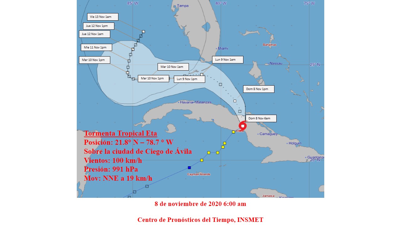
Tropical storm Eta continued its movement with a course near the northeast over the province of Ciego de Ávila and was leaving to the sea on the north coast near Chambas, the Institute of Meteorology publishes.
At nine in the morning its central region was estimated at 22.2 degrees North latitude and 78.9 degrees West longitude, in the vicinity of Chambas, about 40 kilometers northwest of the city of Morón, Ciego de Ávila.
Eta has maximum sustained winds of 95 kilometers per hour, with higher gusts, and its central pressure has risen to 993 hectoPascal. Eta is moving north-northeast at a rate of 19 kilometers per hour.
In the next few hours Eta will maintain a close course between north-northeast and north, tilting its trajectory to the northwest from noon with a slight decrease in its speed of translation.
It is predicted that after a slight weakening while transiting over Cuban territory, Eta, upon emerging into the Old Canal of the Bahamas, will gradually gain in organization and intensity and is expected to be close to hurricane force when it moves through the vicinity of the Florida Keys.
The bands of rainfall related to the circulation of Eta will continue to affect the center and east of Cuba, which will gradually spread to the western provinces and can be strong and intense, mainly in mountainous areas and the central region, even in locations far from the center of circulation of the organism.
In the last 24 hours, the most significant accumulated was recorded in the El Jíbaro station, Sancti Spíritus, with 328 millimeters, followed by the meteorological stations of Júcaro with 163 mm, Venezuela with 158 mm, 142 mm in Falla and Cayo Coco with 113 mm, all in Ciego de Avila.
In the next few hours, the winds with tropical storm force will continue, between 65 and 90 kilometers per hour in the northern portion of the central region of Cuba, with higher gusts, which will gradually decrease from noon.
These winds will produce strong swells on the south coast, with sea level rise between 1 and 1.5 meters and moderate coastal flooding from Júcaro in Ciego de Ávila to Manzanillo in Granma. Due to the combination of the effects of the wind, heavy rains and the sea in the area of ??the mouth of the Zaza rivers in Sancti Spíritus and Cauto in Granma, floods in these areas are forecast to be strong.
In the north coast of the west and center, including the Havana seawall, from the morning strong swells will begin to occur with wave heights of between 3 and 4 meters, generating light coastal floods that will gradually increase until reaching moderate from the end of the tonight. The next tropical cyclone advisory on this organism will be issued at noon today.